 우리에게 전화
우리에게 전화
우리에게 전화


학습 및 사용이 간편합니다
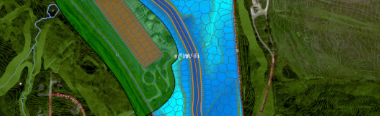
모두와 그래픽 상호 작용
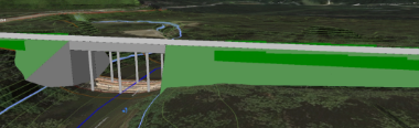
HEC-RAS/HEC-HMS 모델
요소들.

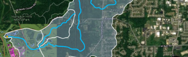
지도에서 직접 작업
Google 지도와 고해상도 혼합
항공 이미지 파일들 바로 그 안에
HEC-RAS/HEC-HMS 모델

CAD 및 GIS 통합
HEC-RAS/HEC-HMS를 AutoCAD
도면 파일, Bentley MicroStation 및
ESRI ArcGIS와 직접 통합하십시오.


다만 그것을 위한 우리의 낱말을 가지고 가지 말라
수천 명의 엔지니어가 우리 제품을 사용하고 왜 그렇게 높게 추천하는지 확인하십시오.

"Lidar 처리 능력과 훌륭한 기술 서비스를 갖춘 우수한 HEC-RAS 인터페이스."

"매우 사용자 친화적이며 기술 지원이 뛰어납니다."
"이 소프트웨어는 표준 HEC-RAS 소프트웨어에서 설계 시간을 대규모로 줄입니다"

수상 및 인정


WhatsApp 에 우리를 도달
Reach us on WhatsApp at
CivilGEO는 새로운 G2 Grid® 엔지니어링 소프트웨어 보고서에서 팩의 최상위에 있습니다
GeoHECRAS 및 GeoHECHMS의 직관적이고 고급 워크플로우를 사용하여 엔지니어링 프로젝트를 절반으로 완성하십시오.

CivilGEO 리뷰
4.8/5.0 등급, G2에 대한 230 이상의 리뷰

GeoHECRAS는 G2에 대한 230 이상의 실제 사용자 리뷰로부터 5.0점 만점에 평균 4.8점으로 최고의 토목 설계 소프트웨어로 인정받고 있습니다.


WhatsApp 에 우리를 도달


Close Popup
CivilGEO, Inc.
Privacy Settings
When you visit any web site, it may store or retrieve information on your browser, mostly in the form of cookies. Control your personal Cookie Services here.
These cookies are necessary for the website to function and cannot be switched off in our systems.
In order to use this website we use the following technically required cookies
For perfomance reasons we use Cloudflare as a CDN network. This saves a cookie "__cfduid" to apply security settings on a per-client basis. This cookie is strictly necessary for Cloudflare's security features and cannot be turned off.